Translate

Sunday, August 30, 2015

Petit Jean State Park, Arkansas --- Part One


Roger here...  After three sometimes stressful days of driving south from Dayton, Ohio, we arrived in what we both refer to as a slice of heaven.  Months ago we asked friends of ours from Retama Village about their favorite places in Arkansas.  Based on their suggestions, we picked three destinations to spend week-long stays.  It helps to have good friends who have lived in the areas we want to visit.  Thanks Eddie, Mary Catherine, Larry and Sharon.  We owe you!

The picture above shows our view from our full-hookup site at Petit Jean State Park.  The peaceful lake in the background through the pine trees is Lake Bailey.  


The sites here are huge --- concrete patio with a separate space (surrounded by rock pavers) for setting up a tent or screen house.  We had no need to do that since our motor home was situated to provide full afternoon shade.


There was plenty of room to set up the dogs' Coolaroo outdoor beds.  The space between individual sites was incredible.  This was the nicest state park camping site that we have encountered in our seven years of rving, and we got to stay for seven days!


This is a photo of one of the typical pull-through sites.     There were only a few other campers here during most of our stay, until the weekend warriors and their happy kids arrived.  After the weekend they all left :-). 

Hiking is often the attraction for us, especially in state/national parks.  It is even more fun when we can take the dogs with us.  Good for them.  Good for us.  We hiked every day that we were here on trails that rivaled those of many of the national park trails we have enjoyed.  We hiked so much, and took so many pictures that we are dividing this blog into three separate posts.  

Hike/Bike trail, Mather Lodge, Cedar Falls Overlook...

After a good night's sleep we awoke to perfect weather --- low humidity, sunny, highs in the low 80s.  What a gift to enjoy weather like that in August in the south!  We leashed up the dogs and embarked on what would be a five-mile hike. 


A 1 3/4 mile paved bike trail connects the camping area to the Mather Lodge.  There were no bicycles -- or other hikers, for that matter -- during our first walk.  We enjoyed the peace and quiet.


Passing the Visitor Center....


... we walked by a bronze statue that commemorated the work of the Civilian Conservation Corps during the great depression.  The intricate stonework and beautifully designed buildings in this park would not have been built without the efforts of the young men of the CCC.


This chimney is all that remains of the recreation hall that was used by the CCC workers.  The fireplace was two-way, creating warmth both inside and outside.   Many of the workers had families back home where they sent their $1/day wages.


CCC Water Tower

After another stroll through the woods we came upon this interesting structure.  We discovered that it was the original water tower for the state park.


As the trail opened up and the first of many rock formations appeared we approached the Mather Lodge.

We took turns watching the dogs so that we could see the inside of this classic, rustic structure.  It is a functioning hotel with a swimming pool and a restaurant surrounded by floor-to-ceiling windows.  


A walkway to the side of the lodge, past the pool, leads to an amazing vista.

Roger checking out the view

We soon discovered that Petit Jean State Park is a plateau that sits entirely on the summit of Petit Jean Mountain.   If you have ever read Sir Arthur Conan Doyle's, Lost World, you may be able to picture a place separated from the rest of the world by vertical cliffs.  Petit Jean is very much like that, except, of course, there are no dinosaurs or cannibals.  

View from Lodge Patio

After gawking at the panorama for a bit, we discovered a sign indicating that a view of Cedar Falls was just a half-mile down a side trail.  I consulted my map and discovered that we could easily reconnect with the bike path.  So off we went.  The trail along the side of a deep canyon was great.  Steps like the ones below carved out of solid rock (more handiwork of the CCC) are so much fun.


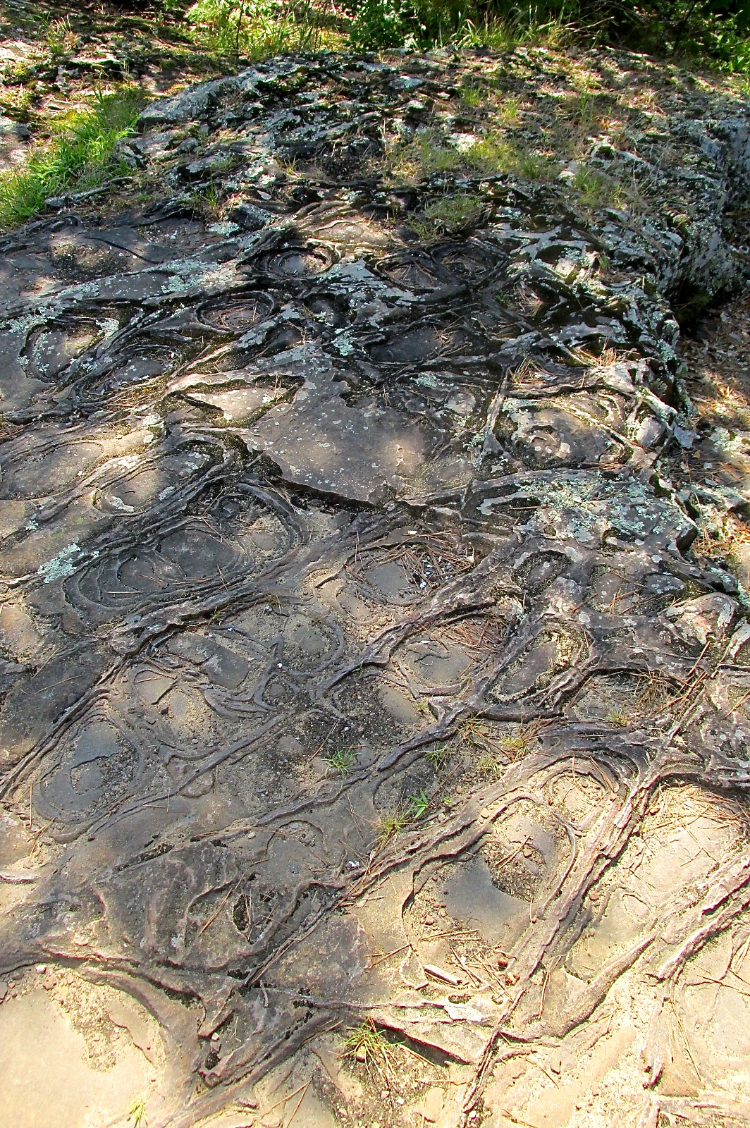
Much of the hiking surface as we approached the overlook was carpet rock.  Carpet rock occurs when cracks in sandstone are filled with iron-rich sediment, forming geometric patterns.  Very unique.


Cedar Falls, the most photographed waterfall in Arkansas, had to be down there somewhere, but where?


The dogs and I took a break next to the stone walls (that kept us from falling into the abyss) while Dianne activated the zoom lens.


Yes Bandido.  I love you, too.

Are the falls there?  They should be.  Don't see or hear 'em.


There they are!  Not much to look at.  A park ranger walked by and told us that the falls are controlled by the dam at Lake Bryan.  Since this is the dry season, not much water is flowing from the lake.  Instead of a rushing waterfall, we saw a tiny trickle. 

Only visible through a super-zoom lens, or younger eyes.


Tequila led the way (until Bandido forged ahead) back to the hike/bike trail along a lengthy series of elevated catwalks.  I love the infrastructure of this park.  The hike/bike trail led us back to our campsite.

C'mon, guys!


After the hike we drove the Toyota to a nearby deli, just outside the park, to buy a few provisions.  During that drive I noticed that we were almost out of gas.  Yikes!  The nearest gas station was 13 miles away at the bottom of the mountain.  We intended to drive the car around the park.  We could not do that unless I risked a trip to the nearest town --- a nagging worry.

Cedar Falls Trail...

The Cedar Falls Trail, which starts behind the Mather Lodge, is touted to be the most difficult hike in the park.  It is only two miles in length, but much of that distance is vertical.  Dianne was not overly excited about this, and I was not overly excited about controlling a dog on all those steps, so I did it alone.  The last time I did a vertical loner (at Yosemite), I had significant knee trouble.  Despite Dianne's worries of a repeat performance, there were no problems on this day.  I walked on the hike/bike trail to the trailhead at the lodge.  I did not dare use any gasoline.

Steep steps carved out of stone.  What a great start!


Down, down, down.....


Lots of switchbacks.  Uh-oh.  This is an out and back trail.  What goes down, must come up.

I have more trouble going down than up.  Good news.  My knees were still fine.


Hiking through the lichen-covered (not bird poop) boulders --- down, down, down.


Near the bottom


Cool narrow bridge across Cedar Creek.


Good move leaving the dogs behind.  Bandido would have hated the narrow bridge with the holes in the floor.


The trail quickly became much easier to negotiate.  Nice walk along Cedar Creek in the bottom of the canyon.


 A short time later I arrived at the diminished waterfall.  A pretty sight despite the lack of gushing white water.


I was the only person on the trail (on the way down).  I spent some time enjoying the serenity of the waterfall and the pond.  I tried to call Dianne to assure her that she did not need to send in the park rangers to rescue me, but there was no phone service --- not a surprise in the bottom of a narrow canyon.


As I heard a family approaching, I decided that it was time to retrace my steps. 


Up, Up, Up!


It really was not too bad.  There were enough level spots along the way to balance the exertion, and honestly the exertion felt good.


I called Dianne when I reached the top and bought a couple of t-shirts for us in the lodge.  The employee at the lodge desk where I paid for the shirts told me that I should risk the 13-mile drive for gasoline, since most of it was downhill.  I thought about it.

 I went back outside, sat on a bench and ate a bologna sandwich that I brought along while gazing at the scenery below.  After a while, I made my way back to the hike/bike path and headed for home.  Two young deer stopped to watch me before bounding into the forest.


My GPS-activated phone app, "MapMyWalk+", indicated that I had hiked 7+ miles, between the trek to the trailhead, the trail, and the trek home.  Good for me.


During our stay, we always walked the dogs around the campground after dinner.  Our route varied from evening to evening, but we often walked near the lake.

Dianne built fires most nights.  She likes doing this, as her friends can confirm.  This was a perfect place for campfires since our neighbors were not nearby and the weather was perfect.


Check back soon.  Our next post will cover two more awesome hikes at Petit Jean State Park, one of them being one of the prettiest hikes we've ever taken.

The pet picture of the day shows Big Chuck enjoying some outdoor deck time.


Friday, August 28, 2015

Adventures in Genealogy (Subtitle: Roger is such a good sport!)

Woodland Cemetery, Dayton, Ohio
Hi all, Dianne here.  Roger told me I have to write this blog entry, about our short stay in Dayton, Ohio.  Roger humors my genealogy hobby, but he has absolutely no interest in it.   Therefore, our side trip to Dayton, Ohio was all about me.  He's such a good sport!   


How I spent my summer....

I'll try to keep this short and leave out much that would be boring to anyone but me.  Therefore, there are no photos of me surrounded by local history books and scribbling notes at the library.  I did spend a lot of time using the microfilm machine to view old Dayton newspapers, and found the 1893 death and funeral notice for Roger's 3rd-great-aunt Harriet Norris Snyder.   That gave me her address, which I also found in several years' worth of old city directories.  By comparing the city directories over the years, I found three addresses where Harriet and her family lived in Dayton.

Harriet Norris Snyder's former Home


I'm glad I tried to find her houses on my way home from the library.  The first two addresses I found are no longer single-family homes.  But, during the last ten years of her life, Harriet lived in the historic Oregon District of Dayton in a lovely 1850 home that still stands and is now on the historic register.  


Gazebo in Park near Harriet's Home

 The next day, while searching for Harriet's  tombstone in Woodland Cemetery in Dayton, I came across some interesting graves:

Erma Bombeck's grave...


I have always been a big fan of Dayton native Erma Bombeck.  I knew that she had an unusual gravestone.   This 29,000-pound rock was brought from near her home in Arizona, where she spent the last 25 years of her life.

There are more than 100,000 Dayton citizens buried in Woodland Cemetery.   Here is just one of the large, grand monuments I saw while there:
Must have been a very important man....

I also found Orville and Wilbur Wright's family plot:
Orville, Wilbur, their parents and little brother (who died young) are buried together here.

The most poignant stone is shown in my opening photo of the boy and his dog.  Little Johnny Morehouse was the youngest son of a local cobbler whose shop was located along the Dayton canal.  While playing near the canal with his constant companion, his dog, Johnny fell into the canal.  His dog pulled him from the water, but he had already drowned.   Local legend says that several days after the burial, the dog appeared next to Johnny's grave, staying by it morning, noon, and night.

The 5-foot-tall marble monument shows details like Johnny's top, his ball, his mouth harp and his little cap, all items which were found in his pocket when he drowned.

(Above info from cemetery literature)

While Woodland Cemetery is a local tourist attraction complete with tours...

 ...my purpose there was to hunt down Harriet Norris Snyder's grave, which I finally found (with a little help from the cemetery office):


Harriet and her husband John Snyder's stones have toppled over and are lying on the ground next to a large tree.  

While it was exciting for me to find Harriet's home and grave, the highlight of my trip to Dayton was finding Roger's 3rd-great-grandfather's grave.   George Norris (Harriet's brother) was born in 1805 and died young, around 1834.  There are no existing Dayton newspapers for 1834 to tell me how he died, and no remaining log cabin or homestead to try to find with my GPS.  I spent a whole year just figuring out who Roger's 2nd- and 3rd-great-grandfathers were.  I have spent so much time researching George and his family that I was determined to find his grave.  


 As opposed to the manicured Woodland Cemetery with its castle-like entrance, the Old Greencastle Cemetery where George lies is neglected, overgrown, and now in a bad section of town.   Roger didn't want me to go there on my own.  I knew he certainly wasn't looking forward to taking me there, so I stopped by the cemetery on my first morning in Dayton, on my way to the library, just to scope it out.

   The cemetery was kind of scary-looking, surrounded by tall fencing with a barbed-wire barrier on top and in a sketchy part of town.  Some of the grass and weeds were taller than my knees.   "Just in case" though, I had brought my hiking boots, shaving cream, mosquito repellant, a plastic scraper and towel (to wipe off shaving cream).  
My cemetery "kit"
When I saw utility workers in the cemetery I decided to "go for it" and look for George.   My library research in Salt Lake City had told me that he was buried in row 11, and that his daughter Catharine was buried next to him, and that her stone was right next to the fence. That narrowed my search.  I had no idea where to start counting the row numbers, or which side they were on, so I started walking the perimeter of the fence.


Catharine's broken, neglected marker face-down in the weeds

 I found Catharine's stone first, now broken and lying face down in the dirt.  I brushed off the debris and smeared it with shaving cream so that I could read what was left of the engraving.

The dates are broken off now, and submerged in the ground, but I already knew from cemetery records that she died at age 19 in 1847.  

George's stone was still standing, and I again used shaving cream (gently removing it with the plastic scraper), to read his stone and photograph it.  I hope wherever George and Catharine are now, that they know at least one person in the world still thinks about them.


While I was doing my own thing in Dayton, Roger stayed behind with the dogs at our spot at Cedarbrook Campground in Lebanon, Ohio.   He didn't really have much choice, since I monopolized the car for two very-full days.  Right about the time he was thinking about putting things away for us to get ready to leave the next morning, I decided to check my genealogy maps to see if there were other relatives who might have lived nearby.

 I saw that my Robison and Parks relatives had once lived in Warren County.  When I checked my on-line family tree on Ancestry.com, I realized that both my 5th great-grandfather Joseph Parks and my 4th great-grandfather James Harris Robison were buried in a cemetery only 6 miles from where we were camped!  To me that meant only one thing:  hop in the car and find them before it got dark.  

I carefully broached the subject to Roger, assuring him that I wouldn't be gone long and that he could stay behind and finish what he was doing.   He wasn't buying that at all; after hearing about Old Greencastle Cemetery, there was no way he was letting me take off alone to another cemetery, especially when it was already 6:00 and nearing dusk.  He definitely wasn't happy about it, but being the awesome hubby that he is, we postponed supper and hopped in the car to find Dick's Creek Presbyterian Cemetery in Turtle Creek Township.

I'm so glad we did!   I had no idea so many Robisons and Parks were buried there.  It is a very, very old cemetery and in bad shape, but extremely interesting.   My 5th gr-gr Joseph Parks had donated the land for the church and cemetery.   The church is long gone, but here are a few of the stones we found:
My 5th great-grandfather Joseph Parks, Revolutionary War Veteran
First we found Joseph Parks' marker.   It was easy to spot because there was a new marker in front of the original (unreadable) one behind it.   We searched and searched for my 4th great-grandfather Robison's grave, but never did find it.   He would have been buried near the Parks graves, because he married Betsy Parks, Joseph Parks' daughter, and was also buried the same month as Joseph Parks, among the earliest graves.

 There were several Parks and Robison markers  with death dates of April of 1814.  They all died during an epidemic of the so-called "cold flu", which actually was epidemic cerebral spinal meningitis, brought to the area by returning War of 1812 soldiers.   Both of my direct great-grandfathers, (5th) Joseph Parks and (4th) James Harris Robison, succumbed that April of 1814, as well as several other sisters, brothers, husbands and wives.

Who said genealogy was boring??  Certainly not me!   Here are a few of the very old stones we saw, most in bad condition at Dick's Creek Presbyterian Cemetery:


Robisons, Robisons
everywhere....


We never did find James Harris
Robison, although he is listed
among those buried at Dick's Creek.  


We saw several broken stones, and others piled 
and stacked.  No way to tell which one was James Harris Robison.
Is this his?
Or this??

James Harris Robison fought in the War of 1812; his grave deserves a small flag and a new marker like Joseph Parks', but his location is lost to the ages. 

My imagination was running wild...what was it like to live in frontier Ohio in 1814?  Or, for that matter, in still-frontier Ohio in 1834 like George Norris?   I feel more research coming on.   Google is my friend!

From Southeastern Ohio we are heading to Arkansas to visit three Arkansas state parks on our slow ride back to Texas.   

To end this blog entry on a lighter note, the pet picture of the day is one of this summer's favorites of Tequila, my quirky little girl.
Just gotta rest my head....